
Baker Lake (BLC) Magnetic Observatory
| Name | Baker Lake |
|---|---|
| IAGA alphabetic code | BLC |
| IAGA numeric code | 026264 |
| Geographic coordinates | 64.318° N, 263.988° E |
| Geomagnetic coordinates (IGRF-12 (2015)) | 72.66° N, 35.47° W (2015.0) |
| Elevation | 30 m |
| First year | 1947 |
| Observatory data | link |
For more information about IAGA, please visit the IAGA web site.
A program of geomagnetic field observations was begun in Baker Lake in 1947. Continuous photographic recording of the geomagnetic field variations using standard LaCour variometers began in January, 1951. Digital recordings began with the Earth Physics Branch's AMOS Mk I in November, 1971. The aging AMOS Mk I was replaced by the AMOS Mk III towards the end of November, 1981. In turn, the AMOS Mk III was replaced by the INTERMAGNET compliant CANMOS in April, 1991.
CANMOS (Canadian Magnetic Observatory System) has been designed by the Geomagnetic Monitoring Service staff, who have developed the software to control the magnetometers and to process the basic digital data. CANMOS includes:
- a commercial tri-axial ringcore fluxgate magnetometer, mounted on a tilt-correcting suspension (of NRCan design)
- an Overhauser Proton Precession Magnetometer
- a bus-clock for timing control
- various storage media
- RS-232 outputs for 1 second, 5 second and 1 minute data streams
The AMOS MK I and III were instruments designed and manufactured by the then Dominion Observatory and Earth Physics Branch. These instruments differ significantly from a commercial version which was also named AMOS.
The area is one of granitic rocks of the Precambrian Shield. The first observatory, erected in 1948, was 3.5 m by 7 m insulated wooden prefabricated building of non- magnetic material with its long axis approximately east- west. Because of accessibility to power and convenience of operation, it was located about 90 m north of the ionosphere station of that time. Instrument piers consisting of large timbers set in the permafrost were not constructed until December, 1950. Also at that time, a light-tight room was partitioned off for a set of LaCour photographic variometers.
To take advantage of bedrock outcrops for constructing new instrument piers, the second observatory building, erected in the summer of 1956, was located at the top of a low cliff about 180 m northwest of the previous site. The new observatory consisted of an insulated aluminium prefabricated building 4.5 m by 6.4 m, erected with its long axis in geographic north-south. A light tight room, approximately 4.5 m by 2.5 m and 2.5 m high, was partitioned off for a set of RUSKA photographic variometers. Concrete piers on bedrock were poured for the photographic variometers and absolute instruments.
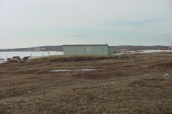
The second observatory building was not really large enough to house all the variometers and absolute instruments together with their associated electronic components. The present observatory building, designed to accommodate both the variometers and the absolute instruments, was built in the fall of 1967. The building, 12 m by 6 m, is non- magnetic throughout. It is situated with its long axis oriented geographically north-south and is located about 55 m east of the second building. Individual instrument piers were eliminated by use of an insulated concrete slab floor. The observatory building has the same construction as the ones in Resolute Bay and Cambridge Bay.